


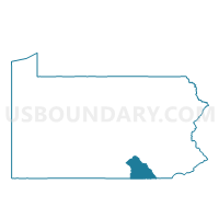
JEFFERSON Voting District, York County, Pennsylvania
About
Outline

Summary
| Unique Area Identifier | 664708 |
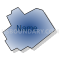
| Name | JEFFERSON Voting District |
| County | York County |
| State | Pennsylvania |
| Area (square miles) | 0.61 |
| Land Area (square miles) | 0.61 |
| Water Area (square miles) | 0.00 |
| % of Land Area | 99.93 |
| % of Water Area | 0.07 |
| Latitude of the Internal Point | 39.81556670 |
| Longtitude of the Internal Point | -76.84061520 |
Maps


Graphs
Select a template below for downloading or customizing gragh for JEFFERSON Voting District, York County, Pennsylvania


Neighbors
Neighoring Voting District (by Name) Neighboring Voting District on the Map
- CODORUS TWP DIST 02, York County, PA
- CODORUS TWP DIST 03, York County, PA
- NORTH CODORUS TWP DIST 02, York County, PA
Top 10 Neighboring County Subdivision (by Population) Neighboring County Subdivision on the Map
- North Codorus township, York County, PA (8,905)
- Codorus township, York County, PA (3,796)
- Jefferson borough, York County, PA (733)